Drone mapping
Our partners :


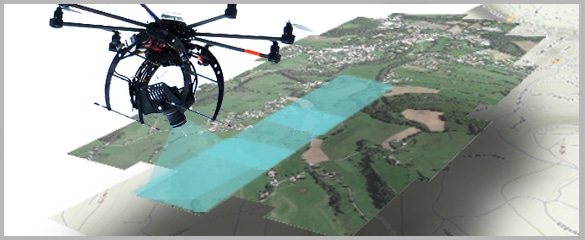
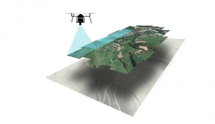
WHAT IS ORTHOPOGRAPHY?
Precise high-definition plans
- ^MORE THAN 300 ORTHOPHOTOGRAPHS
- ^ASSEMBLY OF SEVERAL HECTARES
- ^HIGH PRECISION UP TO 0.1CM/PIXEL
years experience
Our teams are trained in SIG and BIM and master the majority of rendering formats.
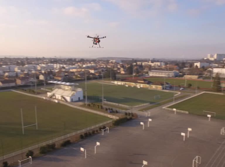
Aerial mapping operations

Thermal mapping

Drone topography
Drone mapping is widely used in construction and land use planning.
Surveyors, design offices, public or private developers and public works companies use it regularly.
Readings are faster than with traditional methods, costs are reduced and risks for personnel are zero. Distance and surface measurements, topographic surveys and cubature calculations are simplified and very precise.

Orthophotography
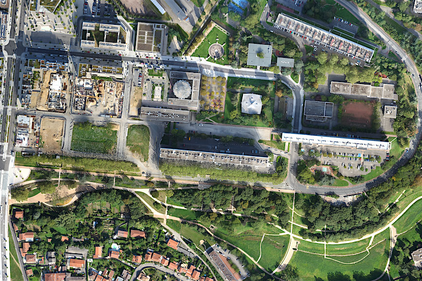
Orthophotography allows to obtain very qualitative aerial views by assembling a very large number of high-definition shots.
These orthoimages are a cheaper alternative to aerial and satellite views. The drone mapping thus produced offers a very high resolution, i.e. an unmatched level of detail.
Orthophotography which is achievable in the visible as well as in the infrared is of interest to many fields: land use planning, works, town planning, environment, agriculture, archaeology, etc.
METHODOLOGY
Drone mapping process
Specification
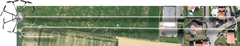
On-site capture
Creation of a secure area, flight plan, orthophotography.
Exploitation of renderings

High-definition plans
Questions about your subject to be mapped?
- 5Development of agricultural crops
- 5Progress of a construction site
- 5Evolution of a wooded area, the coastline, the development of the urbanisation of a sector...
- 5Update of map databases
What is drone mapping used for?
Drone mapping is used to represent an area in plan or elevation, from close-up aerial shots. The drone equipped with a GPS RTK allows to obtain georeferenced maps with great precision.
Aerial mapping allows to carry out a topographic survey, a high-definition plan or even a digital modelling of the terrain in three dimensions.
We can also produce a thermal map showing temperature differences using an onboard infrared camera.
It is then possible to edit the maps in the form of paper plans or to integrate them into a SIG. For greater simplicity and to help you interpret the results, we have developed a dedicated digital tool, available directly via an internet link.
- 548 million pixel sensor
- 5Rainproof IP43-certified drone
- 5Flight time between 20 and 45 minutes
FAQ
Drone mapping
Frequently Asked Questions
What is orthophotography ?
What is the interest of orthophotography ?
 These orthophotographs usually carried out by satellite or by plane were only reserved for large structures due to their cost. The height of the aerial shot greatly limits the final resolution obtained. Drone orthophotography overcomes its limitations. We offer the realisation of orthophotographs of different types: Optical, infrared, near-infrared.
How is the data acquisition carried out ?
 Our system allows for fast and efficient acquisition, and is repeatable over time on a regular basis. This methodology is very useful, for example, for monitoring the progress of a harvest, in hydrography, in forest management or on a construction site.
How is the data processed and for what rendering ?
 The set of photos obtained is associated with the different GPS points of the shots. Our software solution then carries out a correspondence between the images, and proceeds to the constitution of a cloud of points (three-dimensional) allowing the orthorectification of the final rendering. Distortions due to parallax are thus corrected. For some applications, we produce different types of maps for the same terrain (near-infrared and visible for example).
Cross-checking this information allows to obtain different types of indicators, such as the vegetation vitality index. Drone orthophotography allows to obtain this type of data quickly with high resolution and competitive costs. Orthophotos can be exported in different formats and different compression rates to guarantee our customers a resolution and file size adapted to their needs.
The set of photos obtained is associated with the different GPS points of the shots. Our software solution then carries out a correspondence between the images, and proceeds to the constitution of a cloud of points (three-dimensional) allowing the orthorectification of the final rendering. Distortions due to parallax are thus corrected. For some applications, we produce different types of maps for the same terrain (near-infrared and visible for example).
Cross-checking this information allows to obtain different types of indicators, such as the vegetation vitality index. Drone orthophotography allows to obtain this type of data quickly with high resolution and competitive costs. Orthophotos can be exported in different formats and different compression rates to guarantee our customers a resolution and file size adapted to their needs.Which applications for orthophotography ?
The realisation of orthophotography by drone in the visible allows to obtain :
- Extensive inspection : allowing you to quickly inspect large areas.
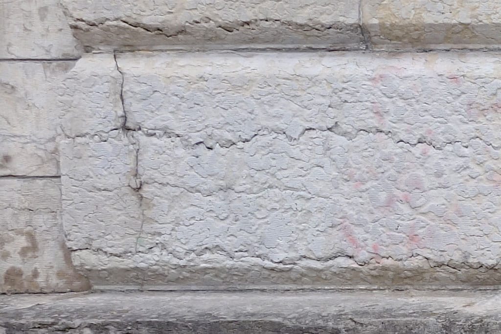
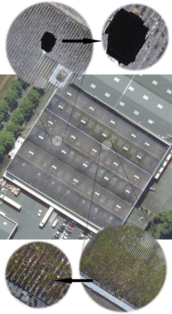
- A precise inspection : access a detailed analysis of your site and defects, up to 1mm/pixel.
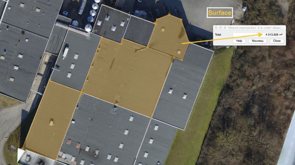
- Digital terrain models (DTM) : giving you access to very precise area / distance / angle calculations on your site.
The fields of application of the drone orthophotography are numerous: land use planning, urban planning, environment, agriculture, archaeology, etc.
Inspection by orthophotography, how does it work ?
 The shots will then be taken by drone by manual piloting or by carrying out an automated flight plan according to the characteristics of the site and the expectation of the resolution of the orthophotography.
After georeferencing and georectification of the orthophotography, we undertake to deliver it to you as soon as possible accompanied by a digital or paper report.
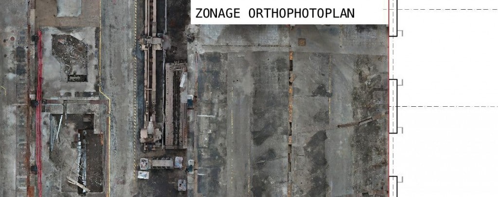
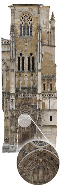
As an example, the following orthophotography required 300 shots with an overlap rate of 70% from one image to another for a total area of 6000 square meters. We obtain a final result with a definition of about 3 cm/pixel, allowing a detailed analysis of the structure :
The shots will then be taken by drone by manual piloting or by carrying out an automated flight plan according to the characteristics of the site and the expectation of the resolution of the orthophotography.
After georeferencing and georectification of the orthophotography, we undertake to deliver it to you as soon as possible accompanied by a digital or paper report.
As an example, the following orthophotography required 300 shots with an overlap rate of 70% from one image to another for a total area of 6000 square meters. We obtain a final result with a definition of about 3 cm/pixel, allowing a detailed analysis of the structure :
What is near-infrared orthography ?
Near-infrared drone orthophotography is mainly used in the detection of plant species and the measurement of soil moisture. The possibilities are nevertheless numerous: vitality maps of the plant cover, infestation map, rate of plant cover, disease detection, diagnosis of heterogeneity, etc.
This technology allows to carry out your diagnostic missions quickly, inexpensively and reliably when combined with a drone.
For the realisation of an optimal orthophotography, it is necessary to choose the meteorological conditions with precision (date, time, level / inclination of the sun). At the end of the service, we provide you with a paper or digital report of your analysis area.
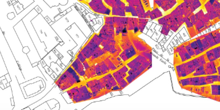
What is thermographic drone orthophotography ?
Thermographic drone orthophotography is a fast, affordable solution capable of treating large areas. It is useful in the analysis of heat networks and the thermal coverage of homes.
HEAT NETWORKS
Infrared orthophotography in the context of heat networks allows the identification of urban heat networks.
This overview remains one of the best methods for inspecting buried networks, because it allows the rapid visualisation of the hot spots of the installation (“hot spots”). The detail of the snapshots greatly facilitates the identification of any anomalies and repair works on the network.
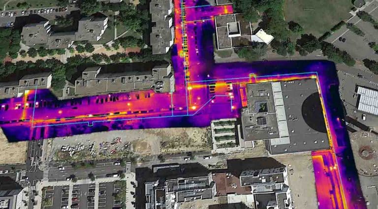
This type of drone orthophotography also allows us to precisely establish the route of the network and to correct the GIS (Geographic Information System) of the operator.
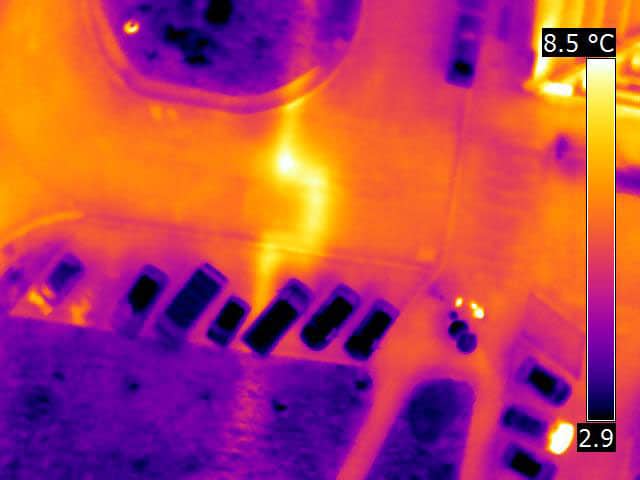
BUILDINGS
Infrared orthophotography in the building allows the overview of residential areas and the detection of possible heat leaks. It allows a global and quick view of your entire site after assembling the thermographies.
You can then have a reference plane comparison/thermal orthophotography to identify the different areas of thermal weaknesses and the insulation of the structures.

- 8, rue de la Madeleine - 69007 LYON
- 04 37 28 67 25
- contact@studiofly.fr